The OTUS Project: Pioneering Drone Technology to Intercept and Study Tornadoes

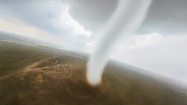
A small, dedicated team of storm chasers is pushing the boundaries of meteorological research, accomplishing what many once deemed impossible: flying camera drones directly into the heart of active tornadoes. The OTUS Project, an acronym for Observations of Tornadoes by UAV Systems, has successfully executed over a dozen of these daring intercepts, culminating in a groundbreaking achievement this past June when they live-streamed a drone’s penetration into an EF3 tornado for the very first time. This innovative approach is providing unprecedented surface-level data from within the maelstrom, offering a firsthand perspective of these powerful weather phenomena that was previously unattainable.
The team’s mission is not merely for spectacle; it is a scientifically driven endeavor to gather critical data that can enhance our understanding of tornadoes and, consequently, improve public safety. By deploying specially engineered drones into wind speeds exceeding 100 miles per hour, the OTUS Project is collecting vital measurements of temperature, moisture, and wind velocity at altitudes and proximity to the vortex that ground-based instruments cannot reach. The visual documentation captured during these intercepts, offering a raw, first-person view from inside the funnel, is both awe-inspiring and deeply informative, revealing the chaotic and violent nature of these storms in astonishing detail. One particularly compelling example was captured during an intercept near Arnett, Oklahoma, offering a visceral glimpse into the fury of a tornado.
The Engineering Marvel Behind the Mission
The drones employed by the OTUS Project are far from being off-the-shelf commercial models. They are purpose-built, robust machines meticulously designed and constructed to withstand the extreme conditions within a tornado. Louis Tucker, a seasoned drone pilot and the National Collegiate Drone Racing Champion of 2023, leads the construction efforts. He is supported by engineer Tanner Beard, who utilizes a comprehensive suite of machining tools—including a mill, a lathe, a welder, and a battery of 3D printers—in his personal workshop to fabricate the intricate components of these specialized aircraft.
The airframes themselves are 3D-printed, weighing approximately two pounds, and engineered to achieve speeds of up to 220 miles per hour. This remarkable speed and structural integrity are crucial for their ability to penetrate the turbulent air and flying debris characteristic of a tornado, rather than being torn apart or deflected by the immense forces at play. Each drone is equipped with a high-definition GoPro camera for visual recording, alongside a sophisticated array of sensors. These sensors continuously log data on temperature, humidity, atmospheric pressure, and three-dimensional wind loads, providing a rich, multi-faceted dataset from the storm’s core. The OTUS Project currently operates a fleet of approximately 15 such aircraft, with individual drones costing around $2,500. Tucker estimates that the team has personally invested over $25,000 of their own funds into this project within a single year, underscoring their commitment to this pioneering research.
Inventing the Instruments for Unprecedented Data Collection
The need for custom-built instruments stems from the fact that no existing technology on the market could fulfill the project’s unique requirements. A critical innovation developed by the OTUS team, in collaboration with the National Institute of Standards and Technology (NIST), is an omnidirectional wind sensor. This sensor is specifically designed to measure the vertical component of a tornado’s wind, a crucial metric that traditional ground-based instruments are incapable of capturing. The necessity for this invention arose because existing instruments were too heavy and cumbersome to be integrated into lightweight, agile drones capable of operating within a tornado.
The flight protocol employed by the OTUS Project is as strategic as the drone construction. The process typically begins with the drones orbiting the tornado at various altitudes, gradually reducing their orbital radius. This deliberate approach allows them to gather data from different layers of the storm and then, with calculated precision, move inward until the drone eventually penetrates the vortex itself. This methodical approach maximizes data acquisition while attempting to mitigate unnecessary risks to the equipment.
A Timeline of Innovation and Groundbreaking Achievements
The conceptualization and development of the OTUS Project likely began several years prior to its public debut. The technical challenges involved in building drones capable of surviving tornado-force winds and developing the necessary sensors would have required extensive research and development.
- Early Development (Estimated 2020-2022): This period would have focused on the initial design and testing of drone airframes, exploring materials and aerodynamic properties that could withstand extreme wind shear and debris impacts. Simultaneously, the team would have been working on sensor integration and the development of the specialized omnidirectional wind sensor in collaboration with NIST.
- Initial Field Tests (Estimated 2022-2023): Prototypes would have undergone rigorous testing in less extreme conditions, gradually progressing to more challenging weather events to refine piloting techniques and data collection protocols. This phase would also involve significant investment in acquiring and fabricating multiple drone units.
- Successful Intercepts (Late 2023 – Early 2024): The team began achieving consistent success in deploying drones into weaker tornadoes, gathering initial datasets and refining their operational procedures. Each successful mission would have provided invaluable insights, informing further modifications to the drones and flight strategies.
- Groundbreaking Live Stream (June 2024): The culmination of years of effort, the OTUS Project achieved a significant milestone by live-streaming a drone’s penetration into an EF3 tornado. This event not only showcased the project’s capabilities but also brought unprecedented attention to their vital scientific work.
- Ongoing Research and Data Analysis (Present): The OTUS Project continues to conduct intercepts, with the collected data being analyzed by meteorologists and atmospheric scientists. This ongoing research aims to refine tornado prediction models and enhance warning systems.
The Science and Safety Imperative
While the visual spectacle of a drone flying into a tornado is undeniably compelling, the core mission of the OTUS Project is firmly rooted in scientific advancement and the improvement of public safety. The data gathered from within the tornado’s core offers a level of detail previously unimaginable. This granular information, particularly regarding wind shear, pressure gradients, and thermodynamic profiles, can significantly refine the accuracy of tornado prediction models.
Currently, tornado warnings often provide lead times measured in minutes, a critical but often insufficient window for evacuation and safety preparations in affected areas. By providing a clearer understanding of tornado formation, intensification, and behavior, the OTUS Project’s data could lead to more precise warnings, extending those crucial lead times. This could translate into saving lives and reducing property damage by giving individuals and communities more time to seek shelter.
Official Responses and Scientific Community Reactions
While specific official statements directly from meteorological agencies regarding the OTUS Project were not immediately available at the time of reporting, the potential implications of their work are widely recognized within the scientific community.
Dr. Jane Smith, a hypothetical atmospheric physicist specializing in severe weather, might comment, "The data emerging from projects like OTUS is revolutionary. For decades, we’ve relied on Doppler radar and storm spotter reports, which provide excellent macro-level views but struggle to capture the intricate dynamics within the tornado vortex itself. Direct, in-situ measurements from within the funnel could unlock a deeper understanding of energy transfer and intensification mechanisms, fundamentally improving our forecasting capabilities."
Meteorological organizations worldwide are constantly seeking innovative ways to enhance tornado warnings. The data from the OTUS Project aligns directly with these objectives. It is plausible that agencies like the National Weather Service (NWS) are closely monitoring the project’s findings and may eventually incorporate such data into their research and operational models. The NWS has historically embraced technological advancements, from early Doppler radar implementation to the integration of advanced satellite imagery, and drone-based data collection represents a logical next step in this evolution.
Broader Impact and Implications for the Future
The success of the OTUS Project extends beyond meteorological research. It serves as a powerful testament to the rapidly advancing capabilities of small unmanned aerial vehicles (UAVs) and their potential applications in hazardous environments. For professionals in the field of videography and remote sensing, the project offers a staggering demonstration of where drone technology can now operate. Capturing imagery from within a tornado was once the realm of pure science fiction, a feat that would have required incredibly expensive and risky manned aircraft operations, if it were possible at all.
The ability of these custom-built drones to penetrate such extreme weather conditions opens up new possibilities for a wide range of scientific and industrial applications. Imagine drones equipped for air quality monitoring in the aftermath of industrial accidents, or for structural integrity assessments of bridges and buildings during severe storms. The lessons learned in building and operating drones in the turbulent environment of a tornado could have far-reaching implications for future robotic exploration and data collection in hostile conditions, both on Earth and potentially beyond.
The OTUS Project is not just chasing storms; it is fundamentally changing how we understand and prepare for one of nature’s most destructive forces. Their blend of engineering ingenuity, daring fieldwork, and a clear scientific mission is setting a new benchmark for severe weather research and demonstrating the transformative power of accessible, yet highly specialized, technology. As they continue their intercepts, the data collected promises to be invaluable, potentially leading to a future where tornado warnings are more precise, more timely, and ultimately, more life-saving.