Technical Foundations and Integration Capabilities
The core utility of ValTerra lies in its ability to synthesize disparate data streams into a cohesive, render-ready scene. Historically, importing massive urban datasets into 3D software required a cumbersome workflow involving multiple GIS (Geographic Information System) tools, manual coordinate alignment, and extensive cleanup of geometry. ValTerra streamlines this by interfacing directly with the Google Maps Platform or Cesium ion, effectively turning the entire globe into a library of assets.
The plugin provides users with the ability to pull in photorealistic 3D Tiles, which are essential for high-end architectural visualization (ArchViz). These tiles provide geometry, textures, and spatial accuracy that reflect the current state of urban centers. For projects requiring less visual fidelity but greater control over individual building elements, the plugin supports OpenStreetMap integration, allowing users to import roads, terrain, and building footprints as manipulatable 3D objects.
One of the most technically impressive features of ValTerra is its camera matching utility. The developer reports a precision measurement of 0.56 px RMS (Root Mean Square) when aligning 3D scenes with drone photography. This level of accuracy is critical for "photo-compositing," where digital elements must perfectly integrate into real-world footage. When a user overlays a 3D render onto a drone capture, the result is not merely adjacent to the existing landscape; it is spatially locked into it, accounting for perspective, lens distortion, and environmental scale.
The Role of Geolocation and Environmental Fidelity
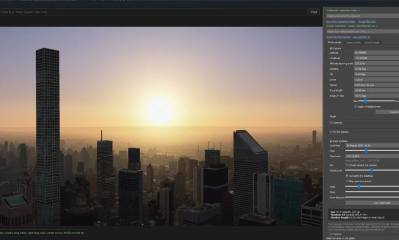
Beyond geometry, ValTerra addresses the challenge of environmental lighting. In professional rendering, matching the light of a scene to the specific time of day and geographic location is a tedious manual task, often involving trial and error with HDRI maps or sun positioning tools. ValTerra automates this by utilizing a 3D globe interface. By selecting the coordinates of the project site and setting the specific date and time, the plugin automatically calibrates the sun’s azimuth and elevation.
This functionality is vital for shadow studies—a staple requirement in urban development and zoning approvals. Architects can now demonstrate with high scientific certainty how a proposed building will cast shadows on neighboring structures at any point in the year, such as during the winter solstice or summer equinox. By tying the sun’s position to real-world coordinates, ValTerra eliminates the margin of error inherent in manual setups, ensuring that environmental impact reports and visual presentations are grounded in verifiable data.
Development History and Professional Context
The development of ValTerra by Shall We Art comes at a time when the ArchViz industry is moving toward "digital twins." A digital twin is a virtual replica of a physical system—in this case, a city—that allows for simulation and analysis. Valerii Nikulin, based in Ukraine, has positioned the plugin to address the specific needs of high-end design firms that require rapid prototyping of urban environments.
The project development cycle reflects a focus on enterprise-level stability. While the software is currently in its initial launch phase, the roadmap indicates a commitment to the 3ds Max ecosystem, specifically targeting users of version 2024 and newer. This ensures compatibility with the latest rendering engines (such as V-Ray, Corona, and Arnold) that rely on the high-performance memory management of modern 3ds Max releases.
The decision to offer a tiered pricing structure suggests an intent to capture both the independent freelancer market and the larger architectural studio segment. By providing a free "Lite" tier after the initial 30-day trial, Shall We Art lowers the barrier to entry, allowing firms to test the plugin’s efficacy on smaller projects before committing to full-scale enterprise integration. The introductory price point of $169 per seat is designed to encourage early adoption as the developer builds out the plugin’s feature set.
Market Implications and Industry Impact
The introduction of ValTerra has significant implications for several sectors, most notably real estate development, urban planning, and cinematic post-production.
In the real estate sector, the ability to visualize a project within its actual context is a powerful marketing tool. Rather than using generic "fill-in" environments, developers can now showcase luxury high-rises or infrastructure projects in a way that respects the existing urban fabric. This transparency can facilitate smoother approval processes with municipal planning departments, who are increasingly demanding high-quality, geolocated visualizations for new construction permits.
In the urban planning sector, ValTerra serves as a rapid-prototyping tool. City officials and consultants can utilize the plugin to import existing site conditions, test the visual impact of proposed zoning changes, or simulate the impact of new transport infrastructure on city skylines. Because the data is derived from globally recognized platforms like Google Maps and OpenStreetMap, the findings are more likely to be accepted by stakeholders as a "single source of truth."
For visual effects and architectural animation, the camera-matching capability is a notable advancement. Previously, achieving a sub-pixel match between a drone-captured environment and a 3D model required expensive specialized software or tedious manual labor. By automating this process, ValTerra potentially reduces the production time for architectural films by a significant margin. This efficiency gain is not just a benefit for productivity; it is a competitive advantage for studios operating on tight deadlines.
Data Privacy and Technical Considerations
The use of Google Maps Platform and Cesium ion tokens introduces a necessary discussion regarding data usage and costs. Users of ValTerra must manage their own API keys or tokens. This is a standard practice in modern software that utilizes third-party map data, as it allows the service provider (Google or Cesium) to bill for high-volume usage directly.
While this adds a layer of configuration for the end user, it also provides flexibility. A firm that already has an enterprise contract with Google Maps can leverage their existing quota, while smaller users can operate within the generous free-tier limits provided by these cloud services. The architecture of the plugin is designed to handle these credentials securely, ensuring that the 3ds Max environment remains a safe workspace for proprietary architectural data.
Future Outlook and Conclusion
As the industry continues to integrate GIS data into the standard 3D pipeline, tools like ValTerra are poised to become standard equipment in the architectural visualization workflow. The shift away from manual modeling of cities—which is prone to error and time-consuming—toward the use of "live" data streams is an irreversible trend.
The success of the plugin will likely depend on the frequency of updates and the responsiveness of the developer to user feedback. With the current focus on 3ds Max 2024 and beyond, the plugin aligns itself with the most modern hardware-accelerated workflows. As Shall We Art continues to grow, the integration of more sophisticated terrain data, such as LiDAR point clouds or detailed vegetation mapping, could be the logical next step for the platform.
For those interested in exploring the tool, the trial version is currently available via the official ValTerra website. By offering a transition from a 30-day full-access trial to a permanent Lite tier, the developer is inviting a wide cross-section of the industry to validate the plugin’s capabilities. Whether for a small-scale residential mockup or a large-scale urban development study, ValTerra represents a significant step forward in the democratization of accurate, photorealistic environmental visualization.
The software’s ability to combine the massive scale of global 3D mapping data with the granular precision required for architectural modeling provides a compelling solution for a modern industry that increasingly relies on accurate digital representations of the physical world. As the introductory sales period approaches, it remains clear that the demand for tools that bridge the gap between GIS and 3D rendering will only continue to rise.